CASE STUDY
PARTNER: RICHLAND COUNTY REGIONAL PLANNING COMMISSION
CLIENT: RICHLAND COUNTY REGIONAL PLANNING COMMISSION
PROJECT: PASER AND ASSET EXTRACTION
APPLICATION: PAVEMENT CONDITION SURVEY AND ASSET INVENTORY/CONDITION
EXTENT: 2,800 LANE-MILES
Pavement Assessment/Inventory Survey and Safety Project for RCRPC
The scope encompasses a pavement condition survey for over 2,200 lane-miles and an asset inventory and condition survey for more than 2,800 lane-miles. The asset condition survey consisted of sidewalks, traffic signs, pavement markings, and line striping. The project scope included rural, suburban, and urban areas.
The data was then QC’d by personnel to make sure that the AI captured the asset presence, location, and condition accurately (also called human-in-the-loop quality management in AI terminology). The project unfolded across several phases. Our project management approach involved constant and consistent communication through a kickoff and bi-weekly project status meetings. This project leveraged Transconomy’s entire ecosystem for data collection, data processing and data visualization. Data collection consisted of Transconomy personnel driving the entire system capturing right-of-way imagery using our Transconomy Collector application supplemented by other high-resolution cameras. The Collector application is Transconomy’s proprietary software/application that can be installed on an iPhone or Android phone and used to collect imagery that is automatically synced to our cloud (called the Transconomy Hub) for immediate access by our artificial intelligence (AI) team. The imagery was then processed using our in-house AI models which produced a pavement condition score based on the University of Wisconsin PASER rating system. AI models were also used to locate, detect, and rate sidewalks, traffic signs, pavement markings and line striping.
The data was then QC’d by personnel to make sure that the AI captured the asset presence, location, and condition accurately (also called human-in-the-loop quality management in AI terminology).
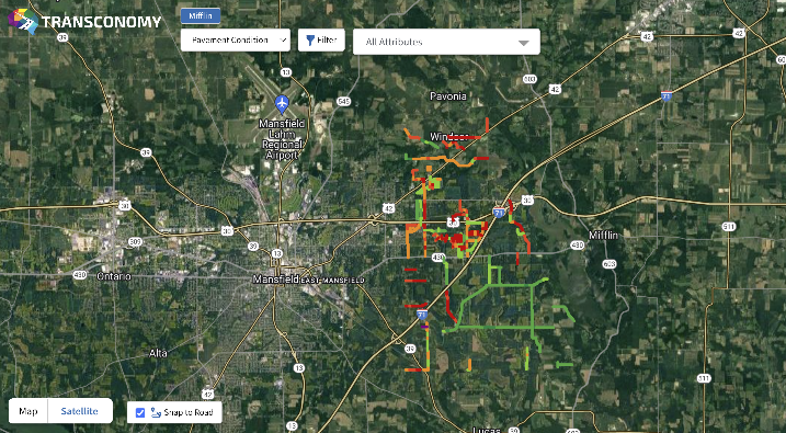
After processing, the outputs were displayed in Transconomy’s custom GIS Viewer system which displays the GPS location, contains an image of the asset, and provides condition information. This tool also contains analytical and filtering capabilities so the RCRPC can view and analyze their data in many different ways. Data is summarized in a dashboard format so information can be presented in an easy-to-comprehend manner for RCRPC stakeholders.
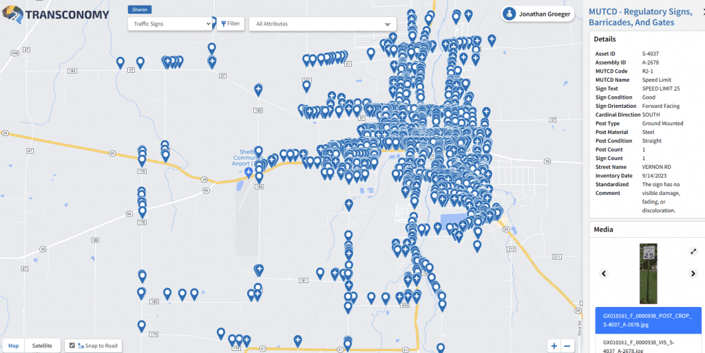
In this project, 19 townships and urban areas were surveyed over 15 person-days, 1,000 lane-miles were evaluated for pavement condition across more than 3,800 roads. 41,000 signs, 1,500 miles of pavement markings, 900 lane-miles of pavement striping and 250 miles of sidewalks were detected, classified, and condition rated. Within the Viewer, users can filter to a specific asset type or condition, identified with a corresponding image that shows the pavement/asset in a contextual manner. RCRPC staff and their stakeholders can perform a virtual “drive-through” of the roadways with the ability to review inventory and condition information.
The gathered data not only aids RCRPC in quantifying and tracking pavement performance but also facilitates proactive planning for future infrastructure needs. It enables the formulation of targeted work plans, ensuring that sidewalks, pavement markings, line striping, and traffic signs are maintained in a state-of-good repair. This comprehensive approach enhances the safety of the public road network system and aligns seamlessly with the Region’s Vision Zero goals, actively contributing to a safer transportation environment and infrastructure for the community of Richland County.
For the RCRPC, the ability to view the comprehensive pavement assessment and asset inventory across the full MPO as well as drill down to individual member agencies empowers near term decision-making and longer-term planning based on accurate, standards-based data. GIS based data makes cross-asset decision making and comparison simpler with an ability to overlay potential programs in mapping programs. From Viewer, RCRPC is able to access data and images to inform reports and presentations for stakeholders, providing clarity for discussions.

The innovative approach to data collection and AI based processing reduced the required time to complete all phases of the project, providing actionable data in a fraction of the time than was previously possible. The approach to the project eliminated the reliance on evaluation teams being present in the field saving time, resources, and enhancing the safety of the teams and the traveling public.
Asset management is a recurring need for all transportation agencies and is a necessary consideration to optimize the performance and cost-effectiveness of infrastructure networks. Between the innovative technology solutions tailored to specific client needs and the wealth of experience within the transportation industry, iENGINEERING and TranSystems are well-positioned to continue to grow their relationship and collaborate on many more asset inventory projects in the future.